
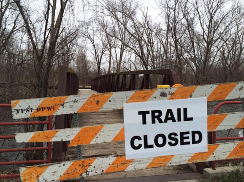
I went to take the dog for a walk this evening and came across the above sign. I had no idea what was going on until I arrived home and found the following note posted to Facebook.
THE BORDER TO BORDER TRAIL LOCATED ON THE WATER STREET DEVELOPMENT PROPERTY IS TEMPORARILY CLOSED, EFFECTIVE IMMEDIATELY
The City is taking precautionary measures because of preliminary environmental test results received today. The new test results indicate an elevated level of PCBs (Polychlorinated Biphenyls) in locations near the trail site. Although PCBs are not a direct danger to humans and pets by occasional contact, long-term and prolonged contact can have harmful effects.
The City is taking proactive measures to protect the health and safety of our residents and needs additional time to complete the full study, assess the level of risk, and create an appropriate containment and remediation plan to provide a safe recreational trail for the community.
More information will be shared when it becomes available.


12 Comments
Paltry Cuts of Beef?
All lies. A republican conspiracy to take over ypsi and divide the spoils.
Wonder if all the volunteers who built the trail with permission from the city’s adopt a park program can sue for negligence that we were allowed to be exposed to potentially dangerous chemicals and given no warning to take precautions by the city?
Trail closed and council wants to give the most valuable plot of land to an affordable housing project the city desperately doesn’t need.
Oh, and that road millage that was going to expire and allow the city to substitute in a Water Street Debt Millage? Yeah, looks like that’s going to be up for renewal after all. Wonder how that effects plans in regards to Headlee limits?
Ralph Lang and council really doing a bang up job lately.
The area where we planted flowers, as I understand it, is likely OK. That area, if I’m not mistaken, mostly consisted of fill dirt brought in from elsewhere. The same goes for much of the sculpture park area behind it. I’ve requested an interview with the city to find out more, though. I’ll keep you posted.
NOTE: This comment was left in response to a comment from “Westside” that was left, I assume accidentally, in another thread. He/she asked: “Is this where the seed bombing, the commons and the knapweed removal all happened?”
I don’t understand how the county and/or state would have approved plans and funding for the B2B trail without making sure the contamination was adequately cleaned up and the area was safe.
Also, going back decades – I don’t understand how businesses were allowed to contaminate this (riverfront) property for years on end, then simply walk away, leaving it to local residents to deal with the contamination and state and local taxpayers to pay to try to clean it up.
They didn’t just walk away, Demetrius. We paid them quite a bit.
The situation is depressing for a lot of different reasons but I doubt the amount of exposure that would occur from walking, riding the trail,or even clearing the trails, are going to have significant health effects for anyone. The earth is a polluted place. Having said that, I always thought it was strange that people who are much more health conscience would have meetings in a place and spend leisure time where there was known contamination.
Again, I don’t think the area where we were planting flowers and making stuff is the area that now has people concerned, but I could be wrong. And, yes, it does concern me a bit, give how much time I spent down there with my kids and digging holes.
Much, if not all, of the contaminants on the site occurred prior to modern environmental regulations. Bulk oil dealer, tool and die operation, gray iron foundary, Motor State Products, etc. I don’t recall a city dump on that property, only at I94 and Bell Street. The maps indicating “hot spots” of contamination were public information back in the early 2000s. My recollection is that there were about three major areas that had a distinct shape and location based on soil boring and historical maps and data from R.L. Polk Directories and Sanborn Fire Insurance maps that listed the types of businesses and building outlines, etc.
PCBs have often been caused by things like exploded power transformers. Most of the contamination I mentioned earlier was below the surface quite some distance.
From MLive.
Read more:
http://www.mlive.com/news/ann-arbor/index.ssf/2016/04/newly_discovered_water_street.html
You left out the most interesting part, Meta.
“The city never made MSHDA’s letter public and council members said Mayor Amanda Edmonds hand delivered the report to council members’ homes instead of emailing it, which isn’t typical.
A concerned resident leaked the letter to The Ann Arbor News, and then the city discussed the issue at the next City Council meeting.”
2 Trackbacks
[…] week or so ago, when I first saw that the Border-to-Border trial through Water Street had been closed, I knew that our days were numbered. I knew that, in time, I’d hear from folks at the city, […]
[…] [The image above shows the Water Street Commons native plant prairie, which was shut down by the City a few days ago, shorty after they closed down the portion of the border-to-border trail that runs through Water Street.] […]