
A few days ago, I posted something here on the site about how there were more people standing on the Mall in DC for Obama’s inauguration than there are living in the entire, sprawling city of Detroit. The post itself wasn’t particularly insightful, but it led to an interesting conversation about Detroit, its declining population, and why it developed in the way that it did over the past century.
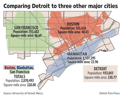
The first comment, left by our friend Ol’ E Cross, referenced an image from the Detroit Free Press (pictured above) that, as he pointed out, illustrated nicely the fact that Boston, Manhattan and San Francisco could fit neatly into the footprint of Motor City, with room to spare. He then made the case that this reflected, “the results of our region’s land use and infrastructure policies.”
But, as Robert was quick to point out, the comparison might not be fair, as these other cities had natural barriers to constrain their growth. Here’s a clip from his comment:
Cool map find, Ol’ E Cross. It should be noted that Manhattan is an island and that San Francisco is located at the tip of a fairly narrow peninsula. If Detroit sprawl had run up against similar natural barriers on all or most sides within a few miles, it’s likely the city limits would have ended there too, and Detroit’s population density would resemble more those of the old coastal cities. Actually, more likely in that case, Toledo would have attracted the shipping and transportation, and we’d all be driving down there to watch the Toledo Tigers, Toledo Red Wings, and Toledo Pistons. The good news would be that we’d have the Detroit Mud Hens, and those Lions would be Toledo’s problem right now. I could live with that…
But, the final comment belonged to city planner Richard “Murph” Murphy, who offered the following:
Not all of that is current land use and transportation policy – a lot of it is a result of the age of the cities, and the eras in which each of them had their growth spurts.
Look to 1900 as a convenient “dawn of the automotive age”.
1. NYC – 3.4m
5. Boston – 560k
9. SF – 343k13. Detroit – 286k
36. LA – 106k.Detroit grew in population 10-fold between 1900 and 1950 – the time when it was growing because of cars. Calling the socioeconomic structure of 1900-1970 “Fordism” is no coincidence; Henry Ford’s theory of “pay them enough that they can afford the product” built Michigan’s middle class by building MIchigan’s market for automobiles.
A city that has its population spike because those people are building and buying cars is a city that will be designed from the ground up around automobiles. LA similarly exploded during and after WWII, when good access to cars was joined by Levittown-style manufacturing of subdivisions, so it too is a city built around detached single-family homes and automobiles.
By comparison, NYC and Boston (and Chicago and Philly) are cities that grew to metropolitan critical mass before ready access to cars or even to single-family homes for the working class. Therefore, they’re cities that are built around proximity – put things close together, and you get density – and the mass transit systems that have to be created in order to keep that proximity from choking up the streets with cars. (I mean, more than they are.)
So, yes, some of it is a result of regional fragmentation pulling people and industry out of the core cities over the last half century. But as Robert notes, there’s also a fair bit of “how far could they expand before hitting boundaries,” whether those boundaries were the Hudson River, the San Francisco Bay, or the Dearborn City Limits.
But a lot of it too just has to do with the state of transportation technology and the housing finance markets at the time that the cities were growing. In no small part, NYC has density because it had density.
I just found this fascinating.
For those of you who don’t care in the least, here’s a link to footage of Arnold Schwarzenegger lifting weights.


22 Comments
Murph/Robert,
Since Mark seems to want to continue the conversation and I haven’t responded…
In 1950 Detroit had a population density of 13,249 per sq mile (Chicago was at 17,450). Now Detroit’s around 6,398 (Chicago is around 12,603).
Currently, Seattle runs around 6,639 per square mile. In 1950, it had 6,604. Not much change. In 1910, Seattle was at 4,243. It’s not always who had it has it.
While Detroit boomed loud(est) in the early part of the last century, so did most metro areas as the population shifted from agriculture to factories and immigrants were imported.
While San Fran and NYC have land issues, other cities without barriers have maintained a higher density than Detroit.
But my point isn’t that our public policies are so much worse than everyone else (although I think we have been a bit more zealous in promoting the auto over transit transport than others … how would Chicago look if it had abandoned the L like we did our streetcars) as our infrastructure policy (from sewers to roads), like many urban regions, has fueled and funded the change. I think, in the very least, it’s a waste of public funds. Here at home and out-of-state.
The thing I find compelling about the map is how much space we’re wasting and the impact: social, economic, and environmental. San Fran, Boston and Manhattan, I think we’d agree, are fairly vibrant, desirable places to live. That if we settled in with one another a bit and invested in projects other than road widening, we could easily absorb the three, I find a bit compelling.
So you both probably know about the most ironic site in Detroit, the once glorious Michigan Theater. It was built on the site Henry Ford built his first auto. Auto profits funded its construction. Auto aided suburban sprawl theaters caused its demise. And, today, it’s a parking garage.
The thing I like most about the map is knowing that with auto induced global warming, eventually San Fran, NYC and Boston will be under water. At which time, Detroit will have more than enough space to house their homeless, and the Michigan Theater may rise again.
I think this discussion is begging for some more specifics. Our SE MI landscape and land use policies are of course shaped by the auto industry, but also by skewed governmental spending at the state and federal level.
–In 1925 MI car companies bought the Interurban Trolley company (which ran between SE Michigan to Bay City to Kalamazoo) and removed all the tracks, creating further dependency on cars in the region.
–There’s the Federal-Aid Highway Act that was passed in 1956 (which happens parallel the demise of Detroit’s cable car system) and funded wide-laned roads to the burbs… and even helped in paving over flourishing urban neighborhoods like Detroit’s Paradise Valley
–the state and federal government transportation funding priorities and trends are aimed at funding primarily outlying areas
–zoning laws separate housing from commerce
–and even the FHA loans starting in the late 40s (which made it possible for middle class America/WWII vets to actually purchase homes) were available only for purchasing new houses in suburban areas- the loans could not be used to buy or rehab a house in the city. (And 98% of those FHA loans were given to white people.)
Just food for thought…
When I think of a good city gone “bad” in the way people are describing, I can only think of my grad school home: Toronto. Lovely downtown, but that city never ends. They looked one way, saw water and just went hog wild in every other possible direction. It’s a passtime of many American progressives to look to Canada for inspiration. Maybe the city planning experts on this site can find better comparisons with Toronto than Chicago. My dad grew up in Rochester, NY and noted that at the time Toronto was a city of comparable importance. Not so any longer.
BTW, as a guy from Brooklyn I find it amusing that “New York” is represented by “Manhattan”. Tell that to the other six million people in the city–many of whom enjoy much lower population density sprawl.
One other thing: the relevance of bringing up the rest of NY is not just representin’. There is no Manhattan as we know it without the rest of the city. Few of the middle and low income people who enable Manhattan to run actually live there.
And I don’t doubt that the “sprawl” around Manhattan, Boston, and San Fransisco is much larger than the “sprawl” around Detroit. And in every case, there are greater numbers of people who choose to live in the less dense areas than those who prefer high density urban environments. The “planners” designed Detroit for higher density and it was for a while – obviously it didn’t work out. People choose to invest in homes where they perceive the quality of life to be optimal and urban planners need to accept the fact that many Americans prefer suburban or rural locations with low density.
A really fascinating book that recounts a lot of the early 20th c. history of Detroit is Mark Boyle’s “Arc of Justice” (I did a review with some interesting links a few years ago: http://imponderabilia.blogspot.com/2006/01/arc-of-justice.html ). Also, Boyle and Victoria Getis did a book of historic photos of Detroit that is pretty eye-opening.
EOS, I think you might have missed much of the substance of the comments above. Folks generally did not choose sprawl. They chose from what was available to them. It’s not that Detroit’s higher density “didn’t work out” as you so pedantically put it. It’s that it was actively taken away to create an automobile culture. We choose from the available choices. In case you missed the research, urban areas are out-growing rural worldwide. People FLOCK to the cities because they want to.
Mark, you have wondered aloud here in the past why your site should continue to exist. I contend it should exist because of posts like these, even if they are few and far between ;-)
Good show! Thank you!
The FHA loans that Sarah mentions were actually designed not to be given to non-whites, mortgage insurance would not be guaranteed by the federal government if blacks were to purchase homes in said subdivisions. The interstates were designed to plow straight through ethnic and minority neighborhoods. I could go on and on… we are suffering the dastardly deeds of generations past and are now left with the mess. The population redistribution in Metro Detroit was planned and purposeful. Anyone who wants reading materials, feel free to email me.
Did anyone else notice the cover of the Free Press today?
Curt –
The exodus from Detroit occurred after the 1950’s, long after the streetcars were torn up. People live near cities because that’s where the jobs are. However the majority live in suburbs or areas further out, by choice. They want low density housing within commuting distance to their jobs.
One of the keys to Detroit’s history is that making cars and car parts was, for generations, so profitable that those industries squeezed out all other industries in the city, aside from those that supported auto. And the city became over dependent on auto – yet as we know full well now, that indsutry did not sustain either its employment levels nor its concentration in the Detroit area. Auto both made Detroit, and brought it down.
Jesus planned Detroit so it must be ok.
Some PEW data on where we supposedly want to live:
http://pewresearch.org/pubs/1096/community-satisfaction-top-cities
You might be unsurprised that Detroit is–I kid you not–the last city on the list. Oh well, as least we live in Ypsilanti!
;-)
Sprawl was and is a choice. It was also advertised and encouraged by both the government, and the corporations that were profiting at the time. Federal spending was used to encourage people to move further away from the city as was described by Sarah above. Ford moved his operations out of the city to Highland Park, encouraging further movement away from the city.
Not everyone should or could live in a high density urban area. But those areas are natural as they build up around industries such as finance and retail. They cost less per person to maintain, cause much less pollution per person than their suburban and rural counterparts and foster creativity and innovation by placing resources in close proximity.
It’s too bad that Detroit, and Michigan never realized, and sometimes still don’t, realize the potential benefits of urban living and a strong core city to anchor the area.
I thought it was accepted that the cause was white fright.
@Vladimir47: That would be why some people left, perhaps. Some people are like that. That’s a sad sad commentary on them. At least, that make me sad.
That doesn’t explain the state the place is *in*. Sometimes you have to take responsibility for the actions of you/ your neighbors.
Not everything can be the fault of others.
dp in exile, email me reading materials fleedermouse@gmail.com I love any info about the planning of the interstates. That shit is unreal when you look at the original maps.
I think everyone is right here. Perfect storm situation in Detroit. White flight, auto industry-dominated power structure, the city burning down at the dawn of the auto age, geography, you all know Ridge road is the old beach right? :/ What else? sheer ignorance and need for individuality, an experiment at urban planning gone bad in the Woodward design, Coleman Young, Oakland Co, inertia, crazy racism and segregation fueling it all maybe because alot of the whites here were from the mid-south? IDK? Perfect storm.
I worked in Highland Park at CHRYSLER for years starting in 1987. I can give you a bit of the picture from that time just before the move to Auburn Hills.
Many of my colleagues at the time had worked for Chrysler since before the riots and lived in Detroit. They spoke of grand culture, safe streets and happy times. Solid infrastructure. Until…Then their faces would get dark and they would speak of how ruined it was. How “they” ruined it. This resentment permeated almost every lunch conversation 20 years later. Still mad as hell and hateful. “They ruined it”. They spoke of the national guard caravans needed to get to work and home during the riots.
Most moved their home by 1969 to either Troy, Warren or Sterling Heights. By late 80s, when I arrived, it was pretty darn ugly.
I was new. I was fascinated watching the gun battles between police and who ever from the 6 story building the used to be on Oakland Ave (yes, we would gather to watch them). I was fascinated by the annual fire rituals of Devil’s night. We got a day off work one year because it was so bad. But then a friend of mine got carjacked on the way to work. Police that didn’t show and clearly didn’t care because he was white. It wasn’t fascinating any more. The stories about the car-part thieves using carpet to get over the razor wire fencing weren’t so interesting after we spent 1/2 a day on lock down because somebody with a gun was loose in our building.
Moving Chrysler’s HQ to Auburn Hills was a HUGE relief to all of us who faced a gauntlet of nastiness each day during our commute and spent our days locked behind armed guards at the gates and doors. The move was not about public policy or having the money to do it. Chrysler’s new HQ was designed to be converted into a Mall should the company go bankrupt before completion because that was a possibility. It was the culmination of an effort to get out of “the cesspool” by that whole company top to bottom. That is what we called it, “the cesspool” and that was in the early 90s. I have no idea what we’d call it now.
Anyone, as an individual, who felt a real choice to leave – especially with those who had kids in public schools – they left for whiter pastures and better facilities, much less crime and much less hostility. I think public policy and planning was a reflection all that not a driver.
As a piece of oak furniture I have no opinion whatsoever of this topic.
Denial,denial, denial. thats what killed Detroit.Q was it Canadian gangs who crossed the river to burn, rape and murder?why did the African American cross 8 mile road? same reason as whites… To get away from the… _ _ G G _ _ _,
the solution? Homesteading, Give land to settlers with clean records and an IQ of at least a 100, cut small villages out of the city, make them all carry a guns.
from 1967 till 1972 Manufacturing was still roaring, Detroit was already starting to die. Model cities !! HA !
This is fascinating stuff. Thank you.
Only one freeway killed Detroit and it wasn’t even in Detroit. The freeway that the War Department built in World War II to connect several west-side suppliers to the Willow Run B-24 bomber plant proved that single-story manufacturing supplied on a just-in-time basis by heavy truck was half the cost to operate of those many old multi-story railroad-supplied factories in the city.
After the war ended factory owners with the money to closed their old inner-city multi-story factories and moved to new single-story factories built in the suburbs in droves, taking their white workforce with them, while underfunded companies were forced to stay in their old multi-story plants in the city and increasingly rendered non-competitive by new single-story suburban plants died in droves.
Before the war, especially in the 1920s, all those big multi-story factories sat on very expensive land along freight railroad lines and paid high taxes. The Great Depression did lots of damage, and then after the war wholesale abandonment occurred fairly quickly after nobody wanted to get stuck with those old multi-story plants. The big 1979-84 double-dip recession probably killed half the remaining old multi-story city factories at that point.
Just between the end of WWII and 1959 nine inner-city Detroit carmakers died. Graham Paige and Hupp both made cars up until WWII, then made war materials during the war, and neither managed to restart car production after the war, though Graham was a major investor in Willys’ Overland division in Toledo. Kaiser Frazier died during the Korean War, and then both Hudson and Nash died right after the Korean War. Hudson by itself used to employ 40,000 workers in Detroit. Then Packard and Studebaker merged and both died, Studebaker not until 1963. Federal Truck and Desoto died in 1959. The deaths of all those companies killed Continental Engine and a number of other city suppliers too. Detroit’s shipbuilding industry died between the 1930s and 1950s too.
Only one freeway killed Detroit and its east end was the intersection of Michigan and Wyoming, right by the Wyoming trolley barn. Parts and sub-assemblies made overnight at a dozen plants near there were rushed by heavy truck to Willow Run and were being assembled into new bombers the next morning. Buses full of war workers also drove on that freeway. Railroads simply couldn’t compete as their supply time was measured in weeks. Railroad-supplied companies had to maintain huge warehouses of assembly parts in-order to keep production running. Companies supplied by truck on a just-in-time basis often only warehouse a 6-hour supply of parts. After the war that freeway eventually became I-94 and also encouraged lots of suburban development along it too.
Many city planners keep whining that Interstate highways killed cities but most of those weren’t even built until the 1960s and 1970s. The damage was done during World War II. Cleveland’s East Shoreway was built by the War Department to connect inner-city suppliers to outlying war plants and 6th Ave freeway in Denver was also built by the War Department for the same reason. There were plenty of other freeways and major divided highways built by the War Department in other cities for the same reason, or to connect cities to major new military bases.
The Housing Act of 1934 and its 20-year 20%-down mortgage only offered to white residents in areas deemed lower risk was another major component of suburbanization after the war. The Lodge freeway was built in 1951 but until the 1960s it was the only freeway that came to downtown. I remember when I-75 was built by Tiger Stadium in the late 1960s. By then the damage was already done. Here is a photo from 1941 of rush hour traffic on Gratiot. By then there had been plenty of suburbanization long before any freeway came to the city.
https://quod.lib.umich.edu/cgi/i/image/api/image/bhl:HS18060:HS18060/full/res:1/0/native.jpg